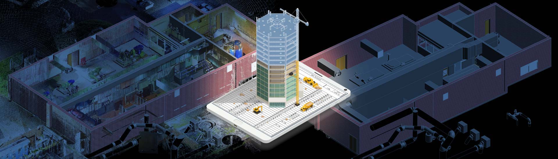

- Modern construction, renovation, and retrofitting involve complexities and risks combined with condensed schedules, creating a shift from legacy surveying to Point Cloud modeling.
- Point Cloud modeling services offer a suite of capabilities driven by best practices, tools, standards, and Level of Development (LOD) for 3D BIM model creation.
- 3D laser scanning for BIM with tools like Revit and ReCAP Pro enable proactive clash detection, greater 3D model precision, higher risk mitigation, and seamless project handovers.
Table of Contents
- Acquisition methods to document Point Cloud data
- Applications of Point Cloud modeling to BIM services
- Key benefits of Point Cloud modeling for risk mitigation
- A quick snapshot of success stories on Point Cloud to BIM services
- Types of risks mitigated with Point Cloud to BIM services
- Limitations of Point Cloud to BIM for construction risk management
- Conclusion
Surveyors and BIM specialists face multiple risks in construction, renovation and retrofitting projects without Point Cloud modeling. Reliance on traditional surveying techniques leads to inaccurate 3D models based on the absence of details and risks of clashes that lead to costly rework. Furthermore, 2D drawings introduce the risk of human error, which can compromise structural integrity. Without precise 3D data, coordination and communication between participants create various obstacles, leading to delays and disputes.
Point cloud data is an important component of 3D spatial analysis and 3D modeling, which offer an agile way to depict environments and objects in a digital space. Point cloud data includes vast datasets represented in a 3D coordinate system. Each point within the dataset is defined by X, Y and Z coordinates, which depict its location in space. BIM specialists and surveyors utilize this information to generate Point Cloud-to-BIM models, which can precisely exhibit physical structures and surrounding spaces.
In this article, we explore the importance of Point Cloud to BIM modeling and Point Cloud to BIM services in mitigating risks for surveyors and surveying firms and for construction projects. Addressing various risks, such as design errors, construction defects, and safety hazards, provides a series of benefits, including preemptive error detection, enhanced collaboration, and proactive risk management.
Acquisition methods to document Point Cloud data
There are various strategies to capture point cloud data using workflows and tools. Here, we examine two methods for documenting point cloud data: laser scanning and photogrammetry.
Laser scanning
Laser scanning uses a focused laser beam to measure object and surface distances. Rapid laser scans across a physical space generate dense point clouds, which represent objects in 3D space. This technique is highly accurate and effective, as it captures minute details and complex geometries.
Photogrammetry
Photogrammetry includes the creation of multiple overlapping images of objects or spaces from multiple angles. Advanced tools assess these photographs and identify common points and features to create a Point Cloud to BIM model in 3D space. This method is agile and cost effective for large-scale projects.
Applications of Point Cloud modeling to BIM services
Point cloud data captured by various techniques and tools like laser scanning and photogrammetry, has become a crucial aspect of the entire project lifecycle. From initial planning and design to construction and ongoing operations, point cloud to BIM for construction surveyors delivers improved insights and foster effective workflows. Let’s understand each application of Point Cloud to BIM services across multiple construction phases.
Pre-construction: Site surveys and clash detection
Point clouds have transformed preconstruction for surveying firms and BIM and CAD professionals by enabling precise site surveys and interference detection. Accurate and data-rich 3D models built from point cloud data support the use of precise spatial information and measurements. Overlaying captured point clouds over design models enables the preemptive identification and resolution of clashes between building elements, mitigating costly rework.
Construction: Progress monitoring and quality control
During the construction process, point clouds help with progress tracking and greater quality control. Comparison of as-built data with the design model helps project managers monitor construction progress, flag deviations from the planned scope, and ensure compliance with specifications. Real-time feedback loops help manage project schedules and reduce costly issues during construction.
Post-construction: As-built documentation
Point clouds make the post-construction process seamless by creating detailed as-built documentation. Accurate 3D models extracted from point cloud data provide a verified and reliable record of the built assets, which facilitates maintenance, facility management, and future renovations. This digital record reduces ambiguities and leads to effective operations throughout the building lifecycle.
Digital twin creation
Point cloud information plays an important role in generating digital twins and virtual replicas of physical assets. Integrating point clouds with data sources like BIM models and IoT sensors provides an in-depth digital representation of how a building is constructed. This supports performance analysis, real-time tracking, predictive maintenance, enhanced building operations, and greater sustainability.
Key benefits of Point Cloud modeling for risk mitigation
Point Cloud to BIM improves risk mitigation by enabling precise As-Built data, fostering clash detection, and improving communication. This lowers rework, errors and delays, which ensures hassle-free handovers and cost savings.
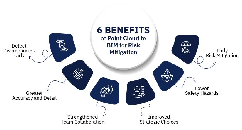
Early error detection
Point Cloud to BIM helps in quick error detection by enabling accurate comparisons between the design model and as-built point cloud data. This enables flagging discrepancies and potential interferences between building components, including structural members, MEP equipment, and architectural features. By identifying these issues in the preconstruction or early phase, project delays and costly reworks can be prevented. This contributes to enhanced project outcomes and cost savings.
Improved accuracy and precision
Point Cloud to BIM modeling improves accuracy for surveying firms and BIM and CAD professionals in construction projects based on a reliable representation of as-built conditions. This data builds a foundation for creating accurate 3D BIM models and reducing ambiguities between the physical and virtual worlds. This improves accuracy, lowers the risk of errors, and ensures building elements are aligned and positioned, enabling improved construction and lower rework.
Enhanced collaboration
Multiple stakeholders improve collaboration between project participants by providing an accurate and data-driven representation of built conditions. This accurate data serves as a benchmark to create precise Point Cloud to BIM models to mitigate discrepancies between the physical and virtual world. This reduces errors during construction, which ensures building components are aligned and positioned, which leads to improvements in construction quality and mitigated rework.
Better decision-making
Providing accurate and detailed data and integrating it within Point Cloud to BIM modeling leads to improved decision-making for the entire construction process. Multiple stakeholders access comprehensive information on existing conditions, design intent, and potential interferences, which foster informed decision-making regarding design changes, risk mitigation, and construction scheduling. This approach reduces uncertainties and enables effective project execution.
Reduced accident risks
Point cloud modeling contributes to mitigating risks by enabling precise analysis and visualization of the built environment. Potential problems, including overhead issues, confined spaces, and uneven terrain, are flagged and resolved in the 3D virtual model before onsite construction begins. This preemptive approach reduces the risk of accidents and injuries, which creates a safe working environment for construction resources.
Proactive risk management
Point cloud to BIM modeling leads to preemptive risk management by enabling the identity and assessment of risks in the early project stages. By assessing the as-built data and 3D design model, project participants can anticipate obstacles, evaluate issues and build risk mitigation workflows. This approach reduces the chances of unpredictable issues and costly problems during construction, which contribute to seamless project delivery and enhanced project success.
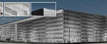
Point Cloud to BIM conversion for a 16th century heritage structure enables quick retrofitting while sustaining monument uniqueness.
A client from the UK specializing in BIM and surveying partnered with HitechDigital to retrofit a 16th century monument while saving its characteristics. Navigating challenges, including a high level of detailing for 580,000 sq.ft., condensed project timelines, and retaining architectural features, the team created 3D Point Cloud to BIM models at LOD 400 for visualization. Cross sections, appropriate levels, and Revit families were generated along with structural components like beams, columns, joists, etc. Upon completion of rigorous QA/QC processes, the detailed 3D models were handed over to the client, which led to:
- Improved decision-making for scheduling and material takeoff.
- Preservation of monument characteristics after retrofitting.
- Project completion within 60 days.
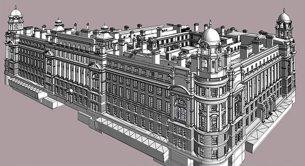 Revit Model at LOD 400
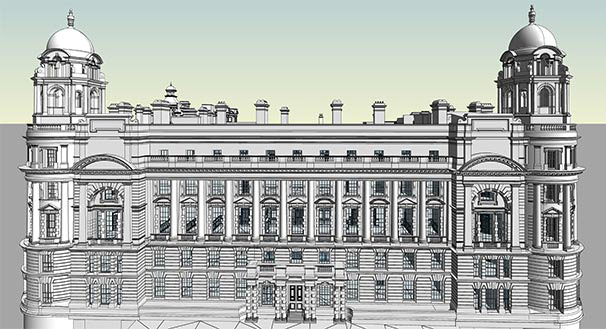 Point Cloud to Revit Model
Types of risks mitigated with Point Cloud to BIM services
The use of Point Cloud data in construction reduces risks across multiple phases. It lowers design errors, mitigates construction problems and reduces safety hazards to prevent schedule overruns and enable cost control.
Design errors
Point Cloud to BIM for construction risk management mitigates design errors by generating accurate as-built data that enable error-free and data-rich Point Cloud to BIM modeling. Clash detection and resolution in a 3D virtual space prevent rework and ensures greater constructability.
Construction defects
Enabling an accurate comparison between the design model and as-built conditions, point cloud to BIM modeling supports the identification and rectification of construction defects. This lowers rework, enhances quality control, and ensure compliance to design specifications.
Safety hazards
Point cloud modeling improves safety by deploying the identification and resolution of hazards on the construction site. Precise 3D models allow for analysis and visualization, enabling preemptive safety measures that reduce accidental risks.
Cost overruns
Laser scanning for BIM projects supported by an accurate and comprehensive 3D model reduces errors, reworks and mitigates material waste. Precise data and efficient processes contribute to improved resource allocation, enhanced construction workflows and complete budget compliance.
Schedule delays
3D laser scanning for BIM makes workflows seamless, enhances coordination, and enables quick problem detection for surveyors and surveying companies. This leads to faster project handovers and lowers the cost impact of stretched construction schedules.
Financial, productivity, environmental and legal risks
Surveyors or BIM companies providing Point cloud to BIM services can utilize their capabilities to mitigate multiple construction risks. Improvements in project results, lower financial losses, and augmented productivity enable conscious construction and reduce legal disputes for surveying teams and their clients.
Limitations of Point Cloud to BIM for construction risk management
While advanced and powerful, 3D laser scanning for BIM poses various challenges. Data accuracy relies on laser scanning quality, and the creation of dense point clouds requires accelerated processing power. Moreover, technical expertise is required for efficient interpretation and implementation of point cloud modeling and for this we often need specialized point cloud to BIM services.
Data acquisition challenges
Acquiring a high-quality dataset to convert a point cloud to a 3D model is challenging based on parameters like site conditions, scanner constraints, and environmental factors like weather and lighting. Inaccurate or compromised data impedes the efficiency of Point Cloud modeling for risk mitigation.
Processing and management complexity
3D laser scanned data is complex and large, which requires greater processing power and advanced software for effective data analysis and management. This creates a hindrance for smaller companies with restricted resources.
Integration and interoperability issues
Integrating point cloud data with BIM tools is challenging due to interoperability problems between multiple platforms. This impedes streamlined data exchange and limits the capability of Point Cloud to BIM workflows.
High initial technology costs
An initial investment in laser scanning equipment, BIM software, and expertise is significant, which can limit the use of Point Cloud to BIM for projects with tight budgets.
Conclusion
Point cloud modeling has proven to be an indispensable tool in modern surveying for construction, renovation and retrofitting projects. It supports surveying firms in overcoming multiple challenges of 2D-based processes, providing streamlined collaboration, reduction in design errors, lower safety hazards, and cost optimization.
Embracing tools like Revit, AutoCAD, ReCAP Pro, and BIM360, and deploying best practices will support the surveying industry and create a path for sustainable AEC innovation.
Turn 3D scan data into accurate BIM-ready models.
Optimize efficiency and reduce rework across every building phases.