
- The old ways of surveying sites are riddled with errors, and require huge labor and time.
- Point Cloud to BIM conversion supports surveyors in modeling as-built conditions from scanned data.
- Surveying accuracy with Point cloud to BIM is enhanced through high-resolution data, ensuring accurate As-Built conditions.
Table of Contents
- Importance of using scan data for BIM modeling.
- Top 4 challenges of using legacy surveying practices.
- How Point Cloud to BIM streamlines surveying.
- Top 3 benefits of creating 3D BIM models from scan data.
- Point Cloud to BIM case studies.
- Top 5 Point Cloud to BIM adoption challenges.
- 8 Best practices of Point Cloud to BIM conversion.
- Future of renovations and retrofitting with Point Cloud to BIM.
- Conclusion
Surveying with laser scans utilizes equipment like LiDAR to capture millions of accurate data points, which generate high-density point clouds. Survey-grade point cloud data is converted into a precise and data-rich 3D model to improve accuracy, visualization, and communication across AEC workflows.
Obsolete surveying techniques and tools fail to provide the accuracy needed to map complex geometries and hard-to-reach spaces. And so, in renovation and retrofitting projects, overdependence on 2D drawings and manual spatial data invariably leads to extended schedules and communication gaps.
A point cloud to BIM model, however, eliminates the need to use such outdated strategies and tools while providing automated documentation. Point Cloud to BIM conversion creates accurate 3D models, mitigates human intervention, and ensures improvements in decision-making for preemptive interference detection and resolution.
Based on a report by Market Research Intellect, the software industry for 3D Point Cloud processing is expected to be valued at $18.88 billion by 2031.
Source: marketresearchintellectImportance of using scan data for BIM modeling.
The importance of building information modeling for surveying is its ability to convert precise and real-world conditions into accurate and comprehensive 3D models. This reduces rework, improves communication and collaboration, and ensures effective renovation and retrofitting for surveying firms and BIM/CAD professionals.
Define Point Cloud to BIM in detail.
Scan to BIM technology converts accurate and detailed laser-scanned data, comprising millions of point clouds, into smart BIM models. Incorporating Scan to BIM best practices into the workflow ensures Point Cloud to BIM conversion documents as-built conditions with extreme precision and enables their representation in 3D space for renovation and retrofitting. Faster coordination and clash detection reduce costly reworks and expedite the approval process with high-quality deliverables.
How do Point Clouds integrate with BIM for surveying workflows?
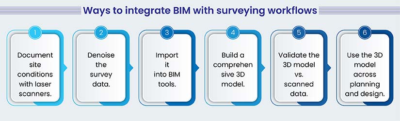
There is a proven process through which point clouds can integrate with BIM for surveying workflows. It helps BIM professionals and surveying companies leverage survey-grade point cloud data to create a coordinated and clash-free point cloud-to-BIM model.
- Surveying with laser scans: Document the built conditions utilizing laser scanners and LiDAR to create a rich point cloud.
- Process surveyed data: Remove noise, register, and align point cloud data to generate a coordinated dataset in 3D space.
- Get data into BIM tools: Use the processed data and load it into model creation and auditing software like Revit or Navisworks.
- Create the 3D model: Generate as-built models for trades, including architecture, structure, and MEPF components.
- Verify the data in the model: Check model precision against captured point cloud data to ensure spatial accuracy.
- Use the 3D model: Use the 3D point cloud to BIM model for faster interference detection and extraction of quantity takeoffs from the 3D model.
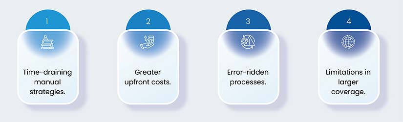
Top 4 challenges of using legacy surveying practices.
Latching onto obsolete surveying practices brings with it various challenges that can produce catastrophic failures for surveyors while renovating or retrofitting projects.
-
Manual measurements lead to higher time consumption.
Manual spatial measurements using chains, tapes, leveling equipment, theodolites, sketching, and field notes are labor-intensive, time-consuming, and inaccurate.
-
Greater initial investment based on equipment and labor costs.
In-house teams are not equipped to survey large spaces, as they require initial investment for labor and equipment. This also leads to higher training costs for utilizing the equipment on-site. Surveying firms may not be able to reap a good ROI if they are small or medium-sized.
-
Higher probability of inaccuracies and errors due to manual intervention.
Manual intervention includes inconsistencies in measurements to record data, subjective results, and handwritten sketches or notes, which lead to frequent site surveys.
-
Limited surveying capability for large-scale projects.
Surveyors also find it difficult to survey hard-to-reach areas, which can lead to missed sites. Surveying large-scale projects with legacy tools is insufficient to capture details. It also leads to lower project efficiency, a higher risk of errors, and difficulties in data integration.
How Point Cloud to BIM streamlines surveying.
The above surveying challenges are resolved by Point Cloud to BIM through various processes and tools. Scan to BIM technology, including LiDAR, drones, and laser scanners, capture data within hours with high accuracy and detail.
Expedite data collection.
Data collection is accelerated while using various advanced equipment like laser scanners, drones, and LiDAR.
-
Utilize advanced LiDAR or laser scanning equipment to document data.
Deploying advanced laser scanning equipment or LiDAR driven by high-frequency lasers, inertial navigation, and multi-return algorithms can help surveyors document spatial coordinates with millimeter-level accuracy. Field calibration in real-time leads to precise georeferencing, reduced drifts, and detailed documentation for reflectance, color, and geometric parameters for downstream analysis.
-
Create dense point clouds in a matter of hours vs days with traditional surveying.
Creating highly dense point clouds in rapid succession shortens the timeline for surveying large sites for renovation and retrofitting. Registration automation integrates with scans, which leads to large datasets in a matter of hours.
Enhance data accuracy.
Data accuracy is significantly improved through survey-grade point cloud data and point cloud to BIM conversion.
-
Use of high-accuracy data points to lower errors.
Millions of accurate point clouds captured with laser scanners eliminate dimensional ambiguities. Millimeter-based accuracy ensures spatial geometry, connections, and component placement in a digital representation, which lowers issues during design, coordination, and renovation.
-
Generate detailed 3D models to achieve improved decision-making.
Point cloud to BIM conversion using 3D BIM models with + -10 mm accuracy improves decision-making and expedites approvals. These 3D models support precision within As-Built data, which supports design validation, scheduling, and cost estimation. Featured accuracy within digital twins also makes coordination seamless among surveyors, BIM professionals, and clients to lower project risks.
Include workflow automation to improve efficiency.
There are various automation workflows embedded within the point cloud to BIM, which include scan registration, segmentation, noise filtering, clash detection, progress tracking, etc.
-
Improve BIM modeling from scan data using conversion automation.
Point Cloud to BIM modeling uses accurate scan data and automation for object recognition with AI/ML tools, for architectural, structural, and MEP disciplines. Tools like Revit reinforced by Scan to BIM plugins ensure geometry extraction for size, shape, and orientation.
Parametric modeling with assigned parameters like dimensions, type, etc. reduces modeling time. Other automation features, templates, batch processing, and assisted automation contribute to greater modeling consistency for large-scale projects.
-
Leverage faster integration with design and construction tools for higher interoperability.
Point Cloud to BIM tools like ReCAP, Revit, Navisworks, and other platforms showcase flexibility, scalability, and seamless integration with third-party tools. BIM professionals and surveyors can leverage interoperability with tools like BIM360 to eliminate data loss and support collaboration in real time.
Top 3 benefits of creating 3D BIM models from scan data.
3D BIM modeling from scan data provides stakeholders with a series of advantages that reduce site visits, resolve clashes, lower rework, and ensure project scalability with accurate resource utilization.
Reduction in labor cost.
Higher labor costs can create a dent in planned budgets for renovation and retrofitting. Point Cloud to BIM supports surveying firms and clients to cut down on labor costs, with a significant reduction in site visits.
-
Cutting down time spent on the site to collect data.
Large projects require multiple site visits if done using traditional methods. However, advanced laser scanning equipment, including drones and laser scanners, can reduce site visits to capture millions of point clouds.
-
Greater site safety while surveying various locations.
Laser scanning done with LiDAR or advanced laser scanning tools ensures sites are safe to survey. Surveying hazardous locations using old tools increases the risk of potential hazards. Laser scanning equipment makes it safer for surveying personnel to scan the entire area, including hard-to-reach areas, which enhances scanning coverage.
Prevent rework with accurate Point Cloud to BIM models.
Rework can significantly create damaging outcomes for renovation and retrofitting projects. Point cloud to BIM can mitigate rework at an early stage.
-
Creation of accurate and data-rich 3D models eliminates design issues.
Design issues emanate from inaccurate and inconsistent survey data. 3D models generated from millions of point clouds ensure every location is mapped and modeled. This lowers design ambiguities in the design stage.
-
Quick detection and resolution of interdisciplinary clashes eliminate rework.
Preemptive identification and resolution of interdisciplinary clashes, including hard, soft, and workflow interferences, reduce rework by a significant factor. Multiple teams collaborating on a single platform and resolving clashes ensure lower change orders and RFIs.
Leverage 3D model visualization and scheduling to enhance resource use.
Visualization and scheduling are key factors that can improve the use of resources during renovation, conservation, and retrofitting.
-
Utilization of advanced hardware and software to increase point cloud to BIM conversion efficiency.
Use of top-of-the-line hardware and software improves the conversion efficiency of point cloud models. Tools like Revit, Navisworks, ReCAP, and BIM360, combined with automation tools like Dynamo, Scripts, APIs, and AI/ML platforms, enhance project outcomes for surveying companies.
-
Enable scalable project execution with rapid ramp-up or ramp-down capability.
Outsourcing Point Cloud to BIM services to expert partners enables greater project scalability. BIM solution providers with extensive experience in workflows and tools can ramp up or ramp down resources as per project needs.
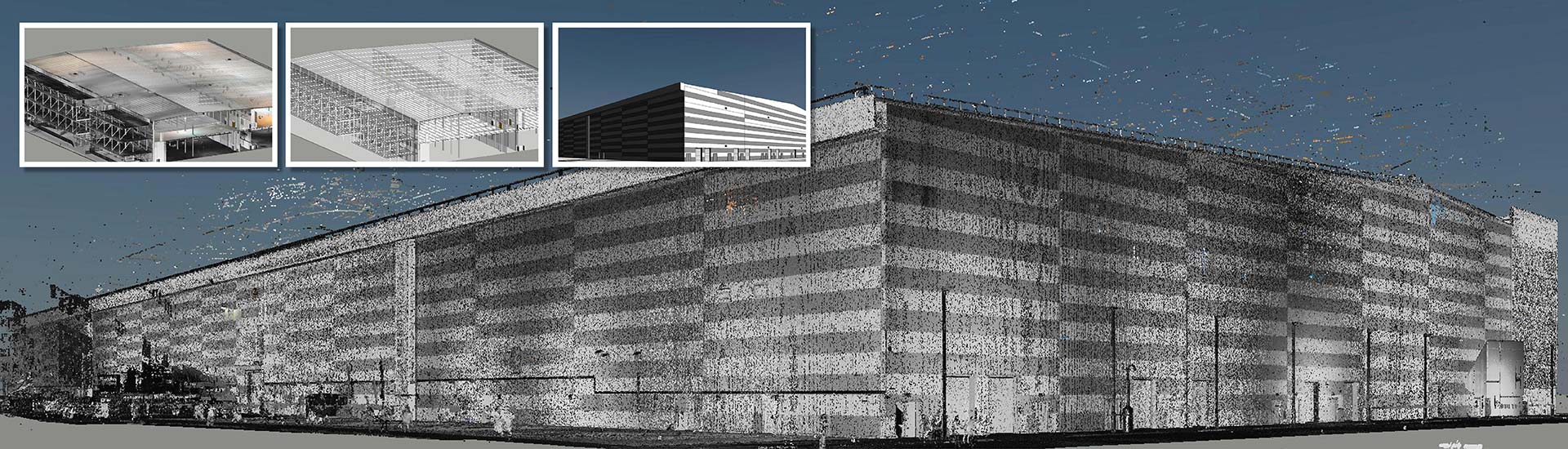
Point Cloud to BIM conversion for a 16th-century monument in the UK improves scheduling.

A surveying firm based in the UK partnered with HitechDigital for monument retrofitting. This was a 16th -century monument whose architectural identity had to be preserved. Therefore, laser scanners were used to document the as-built conditions and to create a 3D model at LOD 400.
The team at HitechDigital analyzed the point cloud scans for shapes, geometries, curves, planes, etc. The scans were converted into a 3D model. Cross-sections, levels, and families were created and integrated within the model. Structural members like beams, columns, joints, etc., were modeled and embedded in the Revit model. Layers of QA/QC processes were set in place to check model validity and data accuracy.
Handing over the deliverables to the client led to:
- Enhanced decision-making, accurate scheduling, and QTOs.
- Retaining monument significance after retrofitting.
- Project completion within 2 months.
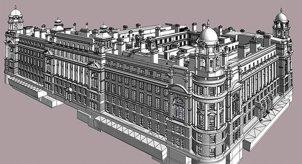 Revit Model at LOD 400
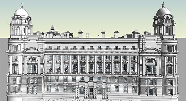 Point Cloud to Revit Model
Top 5 Point Cloud to BIM adoption challenges.
While Point Cloud to BIM conversion offers many benefits, failing to overcome key Scan to BIM adoption challenges can lead to irrecoverable issues.
| Obstacle | Solution |
|---|---|
| Modeling complex geometry. | Use AI-driven automation to achieve feature recognition. |
| Noisy data. | Employ high-resolution laser scanners and integrate filters for preprocessing. |
| Absence of professionals. | Outsource projects to experienced BIM consultants. |
| Hardware and software costs. | Use scalable tools or outsource to specialized Point Cloud to BIM professionals. |
| Manual conversion. | Deploy Scan-to-BIM scripts, APIs, plugins, or rule-based processes. |
8 Best practices of Point Cloud to BIM conversion.
Point cloud-to-BIM model conversion requires best practices that need to be followed thoroughly to achieve the best outcomes.
- Lean toward high-resolution and calibrated scanning with the required scanner settings, registration, and alignment.
- Remove unnecessary data, segment, and classify point clouds, and ensure consistent coordinates.
- Import the point cloud data into Revit and use tools for snapping and point cloud visualization.
- Deploy project-specific LOD, which avoids over or under-modeling.
- Validate 3D model geometry and document tolerances (+–10 mm).
- Organize model components, apply families and parameters, and maintain naming conventions.
- Perform quality checks that are software-driven and run clash detection for architecture, structure, and MEPF systems.
- Handover model and native files with supported documentation, including 3D modeling standards, scan reports, etc.
Future of renovations and retrofitting with Point Cloud to BIM.
AI-driven feature recognition would extend the capabilities of Point Cloud to BIM for renovations and retrofit projects. This would help BIM professionals and surveying firms identify architectural, structural, and MEP components, reduce manual modeling timelines, improve accuracy, and make workflows seamless. The capability to analyze geometric complexities leads to data-driven decisions and higher efficiency in As-Built deliverables.
Conclusion.
Point Cloud to BIM is no longer an option, but a stark necessity for surveyors and BIM professionals to achieve high-quality deliverables that can cut costs and reduce timelines. Renovations, monument restorations, and retrofitting projects will continue to show higher complexities within geometry, material selection, energy calculations, and other capacities. It would require the capabilities of Point Cloud to BIM to resolve these hurdles and achieve impactful project results.
Convert laser scans into data-rich Scan to BIM models.
Connect with our BIM experts for precise Point Cloud to BIM modeling services.