Client Profile.
The client is a leading European surveying firm that focuses on advanced digital surveying and documentation services for various projects including architecture, structure, engineering, landscaping and cartography.
Business Need.
The client was involved in a major land surveying project in Europe. It required creation of 3D drawings extracted from scanned data related to landscaping and road mapping for a particular project area. They needed a comprehensive 3D vector CAD drawing of the location in compliance with local regulations to ensure a streamlined survey process.
For this, they partnered with HitechDigital to get:
- 3D Vector CAD drawings of the entire location.
- Detailed information about building outlines, terrain, roads, landscape features, etc.
Challenges.
The team at HitechDigital evaluated and outlined the Scope of Work (SOW), where various challenges were documented. These included:
- Inferior quality of input data that comprised scanned material and orthophotos, and reduced clarity
- The data did not offer notable delineations of building footprints, that led to our team making inferences based on orthophotos
- Producing precise positioning for vector mapping objectives demanded a very high degree of accuracy across multiple project facets
Solution.
The team at HitechDigtal created a comprehensive 3D line vector CAD drawing of the location that contained information about building outlines, terrain, roads, landscape features, and more. The drawings were content-rich and in the format required by the client.
Project Samples.
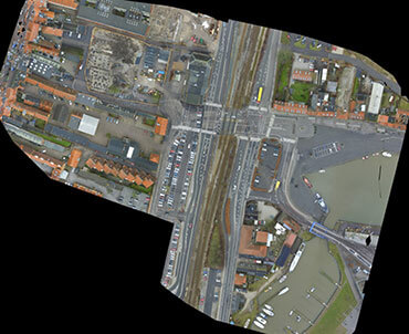 Overall project site
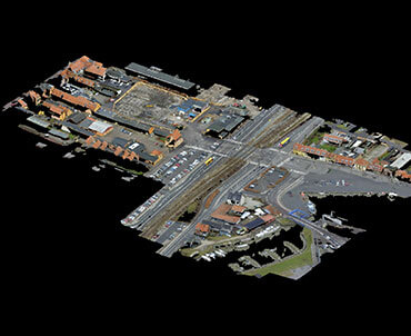
 Point cloud Arial View of Project site
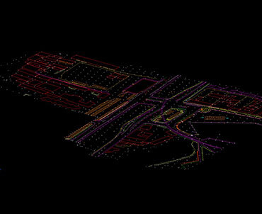
3D Vector Drawing View
Approach.
The BIM team first examined the images and scans provided by the client.
- Once the scans were analyzed, they transformed those images into 3D Vector CAD drawings for land survey area. This included drawing lines, polylines, polygons, and other geometric shapes to represent the surveyed features accurately.
- The drawings were then populated with land survey terrain and road mapping of footprints.
- The team also added annotations, labels, and dimensions to provide context and information about the surveyed features.
- The team created accurate CAD documentation in compliance with local government regulations, to eliminate the likelihood of legal issues.
- The final step included performing quality control checks to ensure that the 3D vector model accurately represented the field data.
- Once all the checks for errors, omissions, and consistency, were conducted, the final deliverable was sent to the client for approval. The client was extremely satisfied with the quality and accuracy of the deliverables.


 Point cloud Arial View of Project site
 3D Vector Drawing View